


Toroda Voting District, Okanogan County, Washington
About
Outline
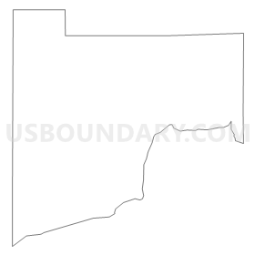
Summary
| Unique Area Identifier | 687724 |
| Name | Toroda Voting District |
| County | Okanogan County |
| State | Washington |
| Area (square miles) | 54.08 |
| Land Area (square miles) | 53.75 |
| Water Area (square miles) | 0.33 |
| % of Land Area | 99.39 |
| % of Water Area | 0.61 |
| Latitude of the Internal Point | 48.75603900 |
| Longtitude of the Internal Point | -119.01903190 |
Maps


Graphs
Select a template below for downloading or customizing gragh for Toroda Voting District, Okanogan County, Washington


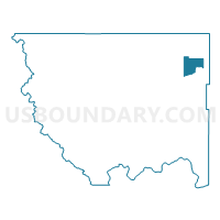
Neighbors
Neighoring Voting District (by Name) Neighboring Voting District on the Map
- Bodie Voting District, Okanogan County, WA
- Havillah Voting District, Okanogan County, WA
- Myers Creek Voting District, Okanogan County, WA
- Sourdough Voting District, Okanogan County, WA
- Wauconda Voting District, Okanogan County, WA
Top 10 Neighboring County Subdivision (by Population) Neighboring County Subdivision on the Map
Top 10 Neighboring Unified School District (by Population) Neighboring Unified School District on the Map
- Tonasket School District, WA (6,638)
- Oroville School District, WA (4,439)
- Republic School District, WA (3,288)
- Curlew School District, WA (1,497)